

144
"The Light Must Unite"
Bill Bishop
Loss Prevention
My Story
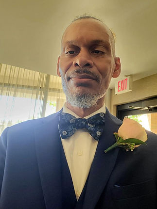
Bill Bishop
GIS Intelligence Expert | Emergency Systems Innovator | Strategic Technologist
Bill Bishop brings over 35 years of cutting-edge experience in GIS intelligence, communications engineering, emergency systems, and public safety technology. Recognized nationally as “The GIS Guru,” he has played a vital role in building and managing systems that support homeland security, disaster response, public health, and community infrastructure.
Bill holds credentials from the American Planning Association (APA ID: 361696), is a member of the New Jersey 911 NENA Association (#64135546), and is a certified UAS Part 107 Administrator. His career includes key leadership positions such as Systems Analyst, GIS Coordinator, IT Special Projects Manager, Radio Communications Engineer, and Network Administrator. He has designed and maintained critical GIS infrastructure for military, federal, state, and municipal agencies across sectors including:
• Public Safety & Emergency Management
• Economic Development & Redevelopment
• Tax Assessor & Zoning
• Urban Planning & Master Plans
• Water Infrastructure & Smart Cities
As a senior-level strategist, Bill has produced and deployed GIS applications that integrate dynamic data services and web-based platforms tailored to the unique needs of public and government sectors. His work has powered decision-making tools in natural resource management, urban development, homeland security, and pandemic response—including COVID-19 systems and UAS (drone) technology applications.
Bill’s extensive military service includes over 30 years in Electronic Command, Control, Communications, Computers, Intelligence, Surveillance, and Reconnaissance (C4ISR) systems. He has built tactical communication networks for U.S. Army units deployed in combat, support, and humanitarian missions. His GIS intelligence and C4ISR contributions include designing operational hubs like Forward Operating Bases (FOBs), Emergency Operations Centers (EOCs), Tactical Operations Centers (TOCs), and Cloud Service Command Platforms. He also supported the Command Post of the Future (CPOF) initiative—providing real-time virtual collaboration capabilities to high-level military leaders.
In his most recent endeavors, Bill is applying GIS and remote sensing technologies to Smart City innovations, water management systems, emergency communications, and advanced public safety infrastructure. He also contributes data to universities across the country through his GIS warehouse platform known as NEWGIN.
⸻
As a key contributor to The Light Must Unite – Opioid Awareness Foundation, Bill’s extensive background in emergency management, digital infrastructure, and intelligent communications systems brings extraordinary value. His ability to architect real-time data environments, support community resilience, and build cross-agency operational networks is critical to the Foundation’s mission. From mapping overdose hotspots to powering coordinated outreach and prevention systems, Bill’s expertise ensures the Foundation is equipped with the tools, intelligence, and infrastructure to save lives.**